Airspace Classification
From ASPMHelp
For more information about airspace classifications, please refer to Chapter 8 in the Instrument Flying Handbook.
Airspace in the United States is designated through the following airspace classifications:
| Class | Description |
|---|---|
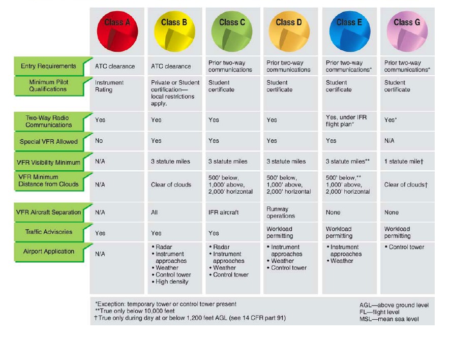
| Class A | Generally, airspace from 18,000 feet mean sea level (MSL) up to and including fl ight level (FL) 600, including the airspace overlying the waters within 12 nautical miles (NM) of the coast of the 48 contiguous states and Alaska. Unless otherwise authorized, all pilots must operate their aircraft under instrument flight rules (IFR). |
| Class B | Generally, airspace from the surface to 10,000feet MSL surrounding the nation’s busiest airports in terms of airport operations or passenger enplanements. The configuration of each Class B airspace area is individually tailored, consists of a surface area and two or more layers (some Class B airspace areas resemble upside-down wedding cakes), and is designed to contain all published instrument procedures once an aircraft enters the airspace. An air traffic control (ATC) clearance is required for all aircraft to operate in the area, and all aircraft that are so cleared receive separation services within the airspace. |
| Class C | Generally, airspace from the surface to 4,000 feet above the airport elevation (charted in MSL) surrounding those airports that have an operational control tower, are serviced by a radar approach control, and have a certain number of IFR operations or passenger enplanements. Although the configuration of each Class C area is individually tailored, the airspace usually consists of a surface area with a 5 NM radius, an outer circle with a 10 NM radius that extends from 1,200 feet to 4,000 feet above the airport elevation and an outer area. Each aircraft must establish two-way radio communications with the ATC facility providing air traffic services prior to entering the airspace and thereafter maintain those communications while within the airspace. |
| Class D | Generally, that airspace from the surface to 2,500 feet above the airport elevation (charted in MSL) surrounding those airports that have an operational control tower. The configuration of each Class D airspace area is individually tailored and when instrument procedures are published, the airspace will normally be designed to contain the procedures. Arrival extensions for instrument approach procedures (IAPs) may be Class D or Class E airspace. Unless otherwise authorized, each aircraft must establish two-way radio communications with the ATC facility providing air traffi c services prior to entering the airspace and thereafter maintain those communications while in the airspace. |
| Class E | Generally, if the airspace is not Class A, B, C, or D, and is controlled airspace, then it is Class E airspace. Class E airspace extends upward from either the surface or a designated altitude to the overlying or adjacent controlled airspace. When designated as a surface area, the airspace will be configured to contain all instrument procedures. Also in this class are federal airways, airspace beginning at either 700 or 1,200 feet above ground level (AGL) used to transition to and from the terminal or en route environment, and en route domestic and offshore airspace areas designated below 18,000 feet MSL. Unless designated at a lower altitude, Class E airspace begins at 14,500 MSL over the United States, including that airspace overlying the waters within 12 NM of the coast of the 48 contiguous states and Alaska, up to but not including 18,000 feet MSL, and the airspace above FL 600. |
| Class G | Airspace not designated as Class A, B, C, D, or E. Class G airspace is essentially uncontrolled by ATC except when associated with a temporary control tower. |

